6 Tage-Tour / Trail zwischen 1800 und 2800 m
6 Tage zwischen 1800 und 2800 Metern über dem Inntal, vom Innsbrucker Patscherkofel, auf durchschnittlich 2000m Höhe über dem Inntal durch die "TuXer" zum Kellerjoch.

6 TuXer Hütten
Patscherkofel Schutzhaus (1970m), am Patscherkofel ob Innsbruck
Glungezer Hütte (2610m) - "höchste Hütte über dem Inntal", ob Hall
Lizumer Hütte (2019m), "in der wilden Lizum im Wattental"
Weidener Hütte (1799m), im Weertal
Rastkogelhütte (2124m), im Zillertal
Kellerjochhütte (2237m), unter'm Kellerjochgipfel
16 TuXer Gipfel
Über 16 Gipfel (und mehr) und acht Jöcher führt der „Inntaler“: Patscherkofel (2246m), Viggarspitze (2306m), Sonnenspitze (2639 m), Glungezer (2677m), Gamslahnerspitze, Kreuzspitze (2746m), Rosenjoch (2796m), Grünbergspitze (2790m), Grafmartspitze (2720m), Naviser Sonnenspitze (2619m), Schoberspitze (2448m), Mölser Sonnenspitze (2450m), Hippold (2642m), Grafennsspitze (2619m), Rastkogel (2762m), Kellerjoch (2344m).
8 TuXer Jöcher
Kreuzjöchl (2575m), Naviser Jöchl (2479m), Mölsjoch (2334m), Klammjoch (2359m), Grafennsjoch (2450m), Nurpensjoch, Sidanjoch (2127m), Loassattel (1675m)
3 Bergbahnen
Für Anstieg bzw. Abstieg: Patscherkofelbahn, Glungezerbahn, Kellerjochbahn
GPX Daten >>>

The INNTALER HÖHENWEG TRAIL
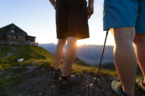
The “Inntaler Höhenweg 2000” is a 6-day high alpine trek that follows the 2,000 m contour line eastwards high above the Inntal Valley, from the Patscherkofel to the Kellerjoch and vice versa. The trail is located at altitudes between 1,800 and 2,800 m and leads through the largely unspoiled, secluded mountains of the Tux Alps.
From Innsbruck/Igls it traverses the Patscherkofel on the Stone Pine Path (Zirbenweg ) to the Glungezer Hütte alpine hut (2,610 m), and along the “Glungezer & Geier” ridge route across the seven Tuxer summits to Lizumer Hütte alpine hut (2,019 m). From here it follows central alpine route 02A over the Grafennsjoch to Weidener Hütte alpine hut, from there over the Nurpensjoch to Rastkogel Hütte alpine hut (2,117 m), to Hochfügen and over the Loassattel to Kellerjoch Hütte alpine hut, before descending to Schwaz.
The “Inntaler” trail runs through the conservation area that encompasses Patscherkofel, Zirmberg and Viggartal Valley, above the Blue Lakes, skirting the Voldertal, Navistal, Wattental, Nafingtal, Nurpenstal, Sidantal and Finsinggrund valleys. The Patscherkofel and the high-altitude chain that continues eastward to the Glungezer afford beautiful views across the Inntal Valley to the Northern Chain and the Karwendel mountains, and as far as the Central Alps to the south. The middle section of the route between Navis Jöchl and Grafennsjoch provides excellent views of the Zillertal valleys. From Kellerjoch the panoramas stretch out towards Innsbruck, the Zillertal Valley and the Karwendel mountains. Wonderful flora and fauna are constant companions on the route.
A 6-day tour between 1,800 and 2,800 m
6 days between 1,800 and 2,800 metres above the Inntal Valley, from the Patscherkofel near Innsbruck, at an average altitude of 2000 m, above the
Inntal Valley to the Kellerjoch.
6 alpine huts in the Tux Alps
Patscherkofel-Haus hut (1,970 m), Glungezer Hütte (2,610 m), Lizumer Hütte (2,019 m), Weidener Hütte (1,799 m) Rastkogel Hütte (2,124 m), Kellerjoch
Hütte (2,237 m)
16 summits in the Tux Alps
The “Inntaler” trail leads hikers over 16+ peaks and eight cols: Patscherkofel (2,246 m), Viggarspitze (2,306 m), Sonnenspitze (2,639 m), Glungezer
(2,677 m), Gamslahnerspitze, Kreuzspitze (2,746 m), Rosenjoch (2,796 m), Grünbergspitze (2,790 m), Grafmartspitze (2,720 m), Naviser Sonnenspitze (2,619 m), Schoberspitze (2,448 m), Mölser
Sonnenspitze (2,450 m), Hippold (2,642 m), Grafennsspitze (2,619 m), Rastkogel (2,762 m), Kellerjoch (2,344 m).
8 cols
Kreuzjöchl (2,575 m), Navis Jöchl (2,479 m), Mölsjoch (2,334 m), Klammjoch (2,359 m), Grafennsjoch (2,450 m), Nurpensjoch, Sidanjoch (2,127 m),
Loassattel (1,675 m)
3 mountain railways
For easier climbs and descents: Patscherkofelbahn, Glungezerbahn, Kellerjochbahn

Through the TuXer Alps from Patscherkofel to the Kellerjoch
Stage 1
Innsbruck/Igls – Patscherkofel – Stone Pine Path (Zirbenweg) – Glungezer hut
6.5 km, 3 hours (easy); +550 m (+1,100 m from Igls)
Access via the Patscherkofel mountain railway or climb via “Heiligwasser”. Starting from Patscherkofel Haus alpine hut (1,970 m) or from the summit
of the Patscherkofel (2,246 m), follow the Stone Pine Path (Zirbenweg) before bearing right onto the path up towards Glungezer Hütte alpine hut (2,610 m), the excellent trekking and ski hut
located at the gateway to the Tux Alps. From here, the Sonnenspitze (10 mins) and the Glungezer (15 mins) are within easy reach. The summit offers stunning panoramic views of 500 peaks, cols and
ridges.
Stage 2
Glungezer hut – seven TuXer summits – Lizumer Hütte alpine hut
14 km, 7-9 hours, red, (1 section black; red option via Tulfeinjöchl - Navis Jöchl); +750m in altitude/-1350 in altitude
The Tyrolean "Eagle Walk" refers to this stage as a seemingly endless series of peaks, which takes hikers from the Glungezer along a mostly flat but
marked to the south across the seven TuXer summits, and over the highest point of the route at the Wattentaler Lizumat (2,796 m). A few passages require some light rock climbing. Route: Glungezer
– Gamslahner – Kreuzjöchl – Kreuzspitze – Rosenjoch – Grünbergspitze – Grafmartspitze – Navis Jöchl – Mölsjoch - Schoberspitze – Mölser Sonnenspitze - Klammjoch – Lizumer Hütte alpine hut (2,019
m), the excellent trekking and ski touring hut in the heart of the Tux Alps, and in the middle of Lizum army training centre.
Stage 3
Lizumer Hütte alpine hut – Grafennsjoch – Weidener Hütte alpine hut
11 km, 6 hours, red; +430 m/-650 m
From Lizumer Hütte alpine hut, follow Central Alpine Route 02A. The route passes the Soldatenkirche (Soldiers’ Church), cutting through ancient pine
forests below Torspitze, Eiskarspitze and Hippold, before leading up to Grafennsjoch. You soon start the descent following Weerbach stream to the Grafennsalm and Weidener Hütte alpine hut (1,799
m).
Stage 4
Weidener Hütte alpine hut – Rastkogel – Rastkogel Hütte alpine hut
11 km, 6 hours, red; +960 m/-645 m
From the Weidener Hütte alpine continue on long-distance trail 302A, heading into the valley alongside the Nafingbach stream, over the Nafingalm
below the Halslspitze to Nurpensjoch. From here you take track 318 to the Rastkogel Hütte alpine hut (2,762 m). The descent follows a green ridge, past two small lakes to Sidanjoch (2,127 m) and
to family-friendly Rastkogel Hütte alpine hut (2,124 m).
Stage 5a
Rastkogel Hütte alpine hut – Hochfügen
7 km, 2.15 hours, red; -650 m
From the hut you return to Sidanjoch (2,127 m), with beautiful views of the Zillertal Alps. The gentle descent continues along track 316 to
Pfundsalm-Mittelleger (1,832 m), along Finsingbach stream heading out of the valley (alternative route via Lamarkalm Niederleger, 1,613 m), to Hochfügen (1,470 m). Possible overnight stay.
Stage 5b
Hochfügen – Kellerjoch Hütte alpine hut
7 km, 3.30 hours, red; +770 m
The onward journey along track 316 from Hochfügen is a gentle climb via Maschentalalm alpine hut (1,717 m) to Loassattel (1,675 m). From here you
can either take the 311 high trail (Hochebenweg) via Naunzalm directly to the alpine hut or continue along trail 316 on the “Kuhmesser” with spectacular views over Innsbruck and the Zillertal
Valley. The route then takes you below the summit to Kellerjoch Hütte alpine hut (2,237 m), an award-winning hiking hut in the Karwendel Silver Region located high above the Inntal and Zillertal
valleys.
Stage 6
Kellerjoch Hütte alpine hut – Schwaz
6 km (to Grafenast), 2 hours, gentle; -900 m (-1,700 m to Schwaz)
It is worth taking a short detour to the Kellerjoch (2,344 m) with its pristine chapel and stunning views of the Karwendel mountains. Descend from
the hut on the Jägersteig trail via the Naunzalm Niederleger and Hochleger, then continue on the Jägersteig trail to reach route 312, the “Alter Kellerjochweg”, to Hochpillberg, mountain station
of the Kellerjoch lifts at Grafenast (1,347 m) and to Schwaz.
East – west route
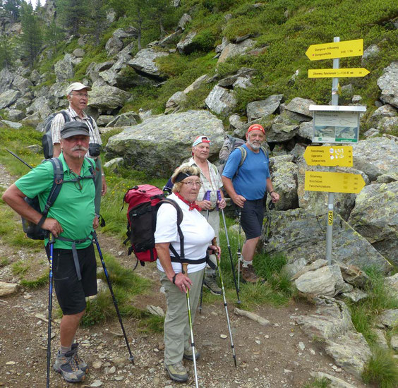
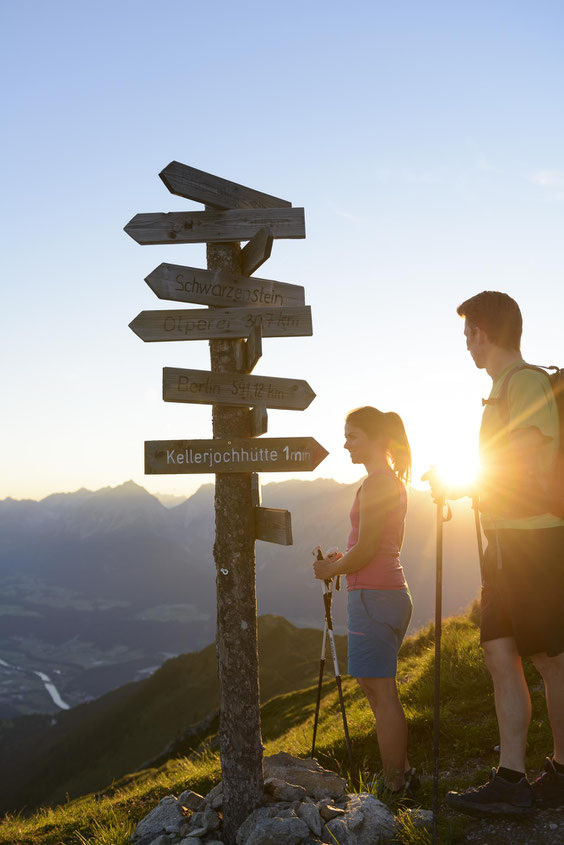
The route is well marked and signposted. It follows existing trails and climbs.
You can also complete the route in the opposite direction, starting from Kellerjoch and heading towards Patscherkofel.
You can start or end the tour at any alpine hut.
The route is well marked and signposted. It follows existing trails and climbs. You can find a route description atwww.tuxeralpen.at.
Mountain huts
Patscherkofel Schutzhaus, 1970 m
ÖAV Sektion TK Innsbruck
Tel. +43/512/377196
info@schutzhaus-patscherkofel.at
www.schutzhaus-patscherkofel.at
Glungezer Hütte, 2610 m
ÖAV-Sektion Hall in Tirol, Hüttengütesiegel
Tel. +43/5223/78018
glungezerhuette@glungezer.at
www.glungezer.at
Lizumer Hütte, 2019 m
ÖAV-Sektion Hall in Tirol, Hüttengütesiegel
Tel. +43/5224/52111 / +43 664 927 2117
info@lizumerhuette.at
www.lizumerhuette.at
Weidener Hütte, 1799 m
DAV-Sektion Weiden
Tel. +43 676
7395997
info@weidenerhuette.at
www.weidenerhuette.at
Rastkogel Hütte, 2124 m
DAV Sektion Oberkochen
Tel. +43/680 22 57 124
rastkogelhuette@t-online.de
www.alpenverein-oberkochen.de/rastkogelhuette.html
Kellerjoch Hütte, 2237m
ÖAV Sektion Schwaz
Tel. 43/664/2202612
info@kellerjoch.at
www.kellerjoch.at
Lizum army training centre (TÜPL)
Shooting times for the Lizum Walchen firing range: For information telephone 050201/6442010 or visit www.wattenberg.tirol.gv.at
Maps
Alpine Association (AV) map 31/5
Federal Office of Metrology and Surveying (BEV) maps 149, 119
Abbreviations
+ m = altitude over climb. - m = altitude over descent
red: medium difficulty mountain trail
black: difficult mountain trail
“Inntaler Höhenweg 2000”
The Inntaler Höhenweg 2000 includes the Tyrolean Eagle’s Way (Adlerweg), Central Alpine Route 02A, Via Alpina, and other routes from Trieste to
Monaco:
Stone Pine Path (Zirbenweg): Patscherkofel – Tulfein - Glungezer
Glungezer & Geier Route: Alpine Association (AV) Route No. 335: Glungezer – Seven Tuxer summits – Lizumerhütte/Wattental.
Eagle’s Way (Adlerweg): Alternative route: Patscherkofel – Glungezer – Lizum
Via Alpina, red, Innsbruck alternative:
www.via-alpina.org/Default.aspx?pageid=page1157
c by gerald aichner